
Players might want to wrap their heads around these maps and plan accordingly for gear, nutrition and hydration. Pay special attention to the aid station locations (more details on aid station mileage and crew access can be found here.) While there are eight fully stocked locations, there are big miles and loads of climbing between them; use an abundance of caution and stock up on calories and liquids before setting out for the next waypoint. Note: click on any of the images or links to view or download .pdf versions.
Elevation profile for the 68 Miler:

The 100 mile option begins at the ~60mile point where the elevation profiles below are run. After the three loops below the above profile for miles 60-68 mile are run to reach the 104+mi finish.
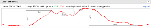
Loop 1
Loop 2

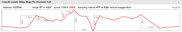
Loop 3
For additional aid station details (type of food, crew access, directions) click here to go to the Aid Station page of this website.
Santa Monica Mountains National Recreation Area Annotated Map with Aid and Cutoffs

Santa Monica Mountains National Recreation Area (au naturale):
Detailed Topographical Maps (these are large-ish files; please relax and enjoy the free time while they load):
- Start – Roads to the starting line
- Section 2 – Will Rogers State Park to The Hub
- Section 3 – The Hub to Fossil Ridge
- Section 4 – Fossil Ridge to Mesa Peak Motorway
- Section 5 – Mesa Peak Motorway to Latigo Canyon Rd
- Section 6 – Latigo Canyon Rd to Etz Malloy Motorway
- Section 7 – Etz Malloy Motorway to Chamberlain Trail
- Section 8 – Chamberlain Trail to La Jolla Canyon finish line
And if that was not enough… here are the loops to round out the 100+ mile options
Loop 1 – Danielson >Coyote Trail > Hidden Pond> Danielson
Loop 2 – Danielson > Serrano Valley > Danielson
Loop 3 – Danielson > LaJolla Valley > Mugu Peak > Chumash Trail > Danielson
After Loop 3 you will follow the traditional finish from Danielson to Wood Canyon Vista to Overlook to Ray Miller trail to the finish as noted in Section 8 above.
Here is an old map we found from 2005 that may help you understand the 3 loops noted above. Pt Mugu State Park Map
